- Distance 7km
- Maximum altitude not disclosed
- Altitude minimum not disclosed
- Walk 03h00
- Positive elevation gain 350m
- Negative elevation gain 350m
- Commune de départ Saint-Montan
Description
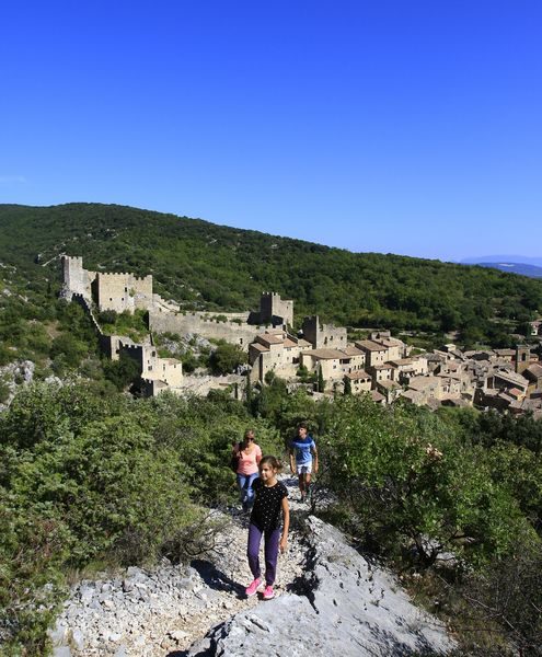
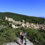
This hike leaves from the village of Saint-Montan and goes around the Gorges de la Sainte- Beaume on a pretty steep path.
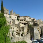
It goes through the Cave of the Hermit Montanus (who gave his name to the village); and, by the Romanesque church of Larnas (view of the lavender and the vines of the Laoul plateau). You'll end up with views on the castle and the medieval village which were completely rebuilt by volunteers.
-
Address
- Quartier Bauvache
- 07220
- Saint-Montan
- website
- Phone 04 75 54 54 20
- Mail Write us
-
Opening
All year round.
Localisation
Departure from the hiking information panel located in the parking of the post office along the D190 which goes from Saint-Montan to Bourg-Saint-Andéol. Carefully follow the PR indications: white and yellow markup. Go north, the old village and its castle (to visit). Cross the bridge to the left on the D262, direction Larnas. Go past the church (drinking water fountain on the right just before it). Cross over a small bridge and continue on the road next to the creek to the San Montana chapel on the right. Climb the path that starts at the wall of the chapel. Small signs will lead you to the Cave of the Hermit (2). The path leading to it leaves the PR markings. Get back on the circuit, be careful, the rocks crossed are very steep. After about 1.8 km of ascent, go down to the right following the PR indications. Whether you continue to climb straight you will shorten the circuit by 500m.
From the post "Bois de Deniéret" (2), the route is on the GR 42: white and red markings. At this post turn left and follow the direction Larnas on the main path, until the crossing with a Calvary on the right. To come down to the nearby road and follow it to the left to descend towards the church, passing next to a old thresher. The Saint Pierre church is a fine example of Romanesque art to visit. Take the road again until crossing and continue straight on the D262 to the nearby town hall where you will find a water point facade and the hiking information panel. Take the small road opposite the town hall, which will take you to the small village. Pass under the porch, then take the Rue des Jardins which goes down along the access to the parking lot of the restaurant. Take then the path. You may have to open and then close a gate/fence. Carefully follow the GR and PR markings.
The rocky path climbs up to the "La Peyrière" post (3). There follow "St Montan, 1.7 km" to the left. Follow the undergrowth path. Climb to the summit, then remain vigilant at the markings on the descent to the village of St Montan. Small junction to the left offer beautiful views. At the junction with several paths: take the one that goes down to the village. Arrived at the village, follow the wall of a house then go down to the paved road. Do not hesitate to visit the very beautiful old village. To return to the car park, go past the church and follow "Bourg-Saint-Andéol". Or, follow the stream to Place Poulallé.
Advice from Vincent: on days following good rains, you can extend this circuit by 4 km to see the Imbours waterfall. For this, arrived at the post "La Peyrière" (3), turn right. At the "Bas Rocher" post (4), go down to the right. At the post "Fountain of Buis" (5), enter through a gate and continue to follow the PR markings until the waterfall, then at the post "Imbours" (6) turn left towards "Bas Imbours" (7) nearby. And there, return to the posts "Bas Rocher" (4) then "La Peyrière" (3). To return to St. Montan. p4 This hike leaves from the village of Saint-Montan and goes around the Gorges de la Sainte- Beaume on a pretty steep path.
It goes through the Cave of the Hermit Montanus (who gave his name to the village); and, by the Romanesque church of Larnas (view of the lavender and the vines of the Laoul plateau). You'll end up with views on the castle and the medieval village which were completely rebuilt by volunteers. Difficult climbs and descents in places, parts on slabs and rockeries. Route not recommended during and shortly after rain because very slippery in places. Circuit almost impassable by mountain bike.
Combinable with the circuit Around Larnas which has a common section